
를 팔로우 했습니다.
팔로우 서비스의 지정 과정에서 문제가 발생하였습니다.
이 사용자의 경우에는 다른 사용자들의 팔로우 서비스를 허용하지 않고 있습니다.
이 사용자에 대한 팔로우 서비스를 이미 이용하고 계십니다.
고객님의 현재 멤버십 등급으로는 0 건까지만 팔로우가 가능합니다. 멤버십 서비스의 업그레이드는 여기에서 하시면 됩니다.
성공적으로 언팔로우했습니다
팔로우 서비스에 대한 지정 해제 과정에서 문제가 발생하였습니다.
님에 대한 고객님의 추천 절차가 모두 완료되었습니다.
사용자 추천 과정에서 문제가 발생하였습니다.
원인을 알 수 없는 문제가 발생하였습니다. 현재의 페이지에서 다시 읽기 버튼을 클릭하신 후에 재시도하여 주시기 바랍니다.

직업에 관해 Ayoub L.님에게 연락해보세요
채팅으로 자세한 내용을 논의하려면 로그인하세요.
포트폴리오
포트폴리오

Spatial analysis

Spatial analysis
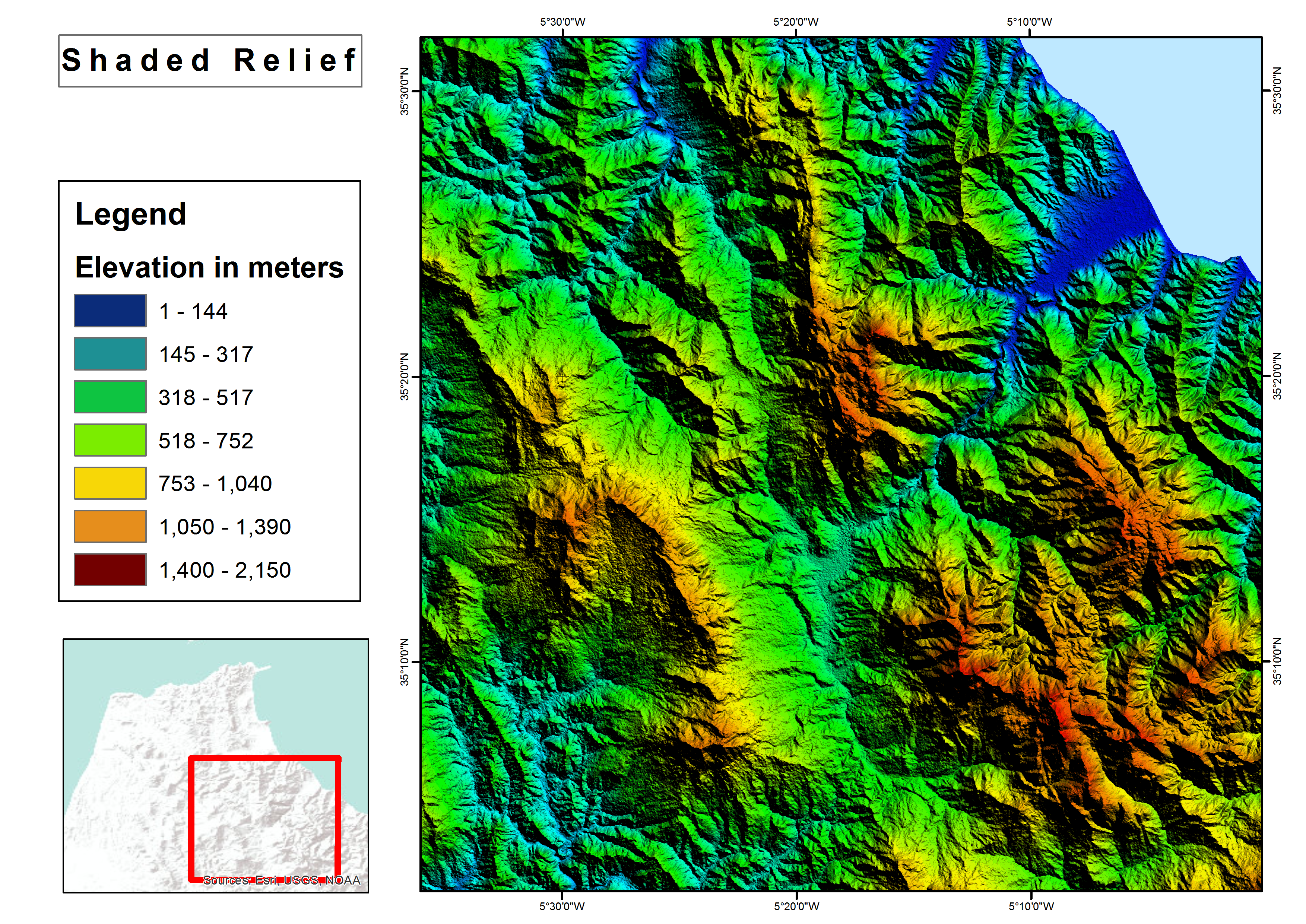

Shaded relief map
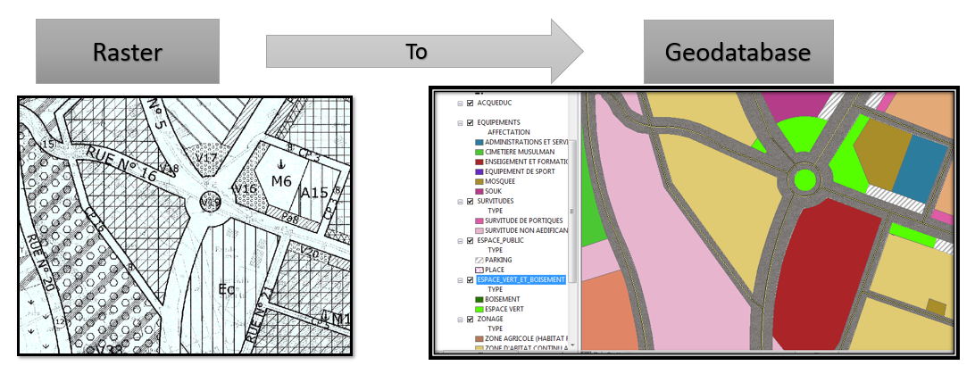

Raster to Geodatabase
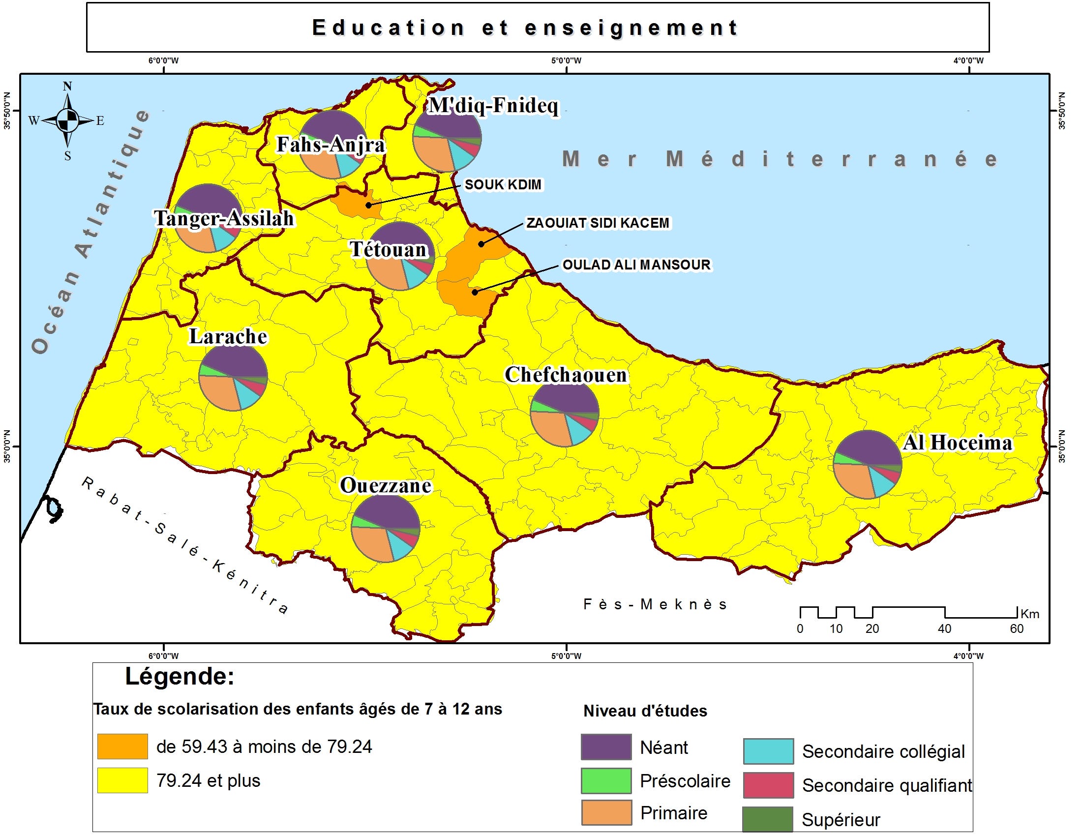

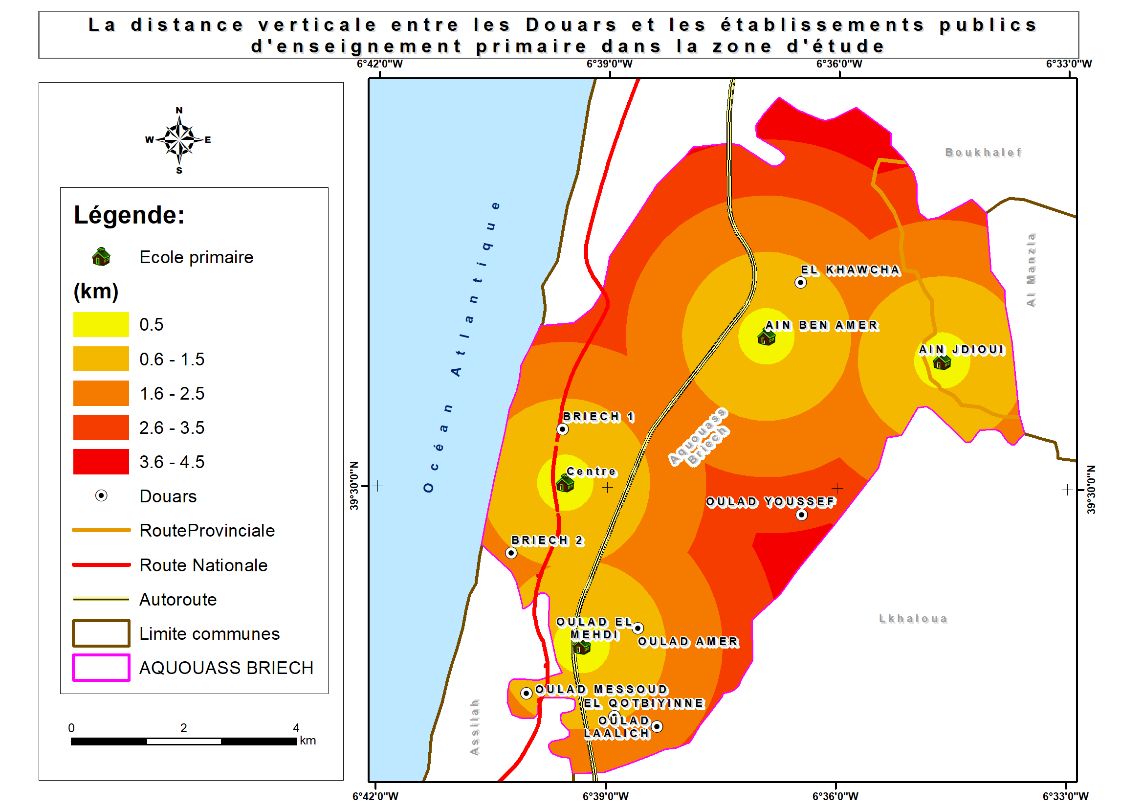
Thematic maps

Thematic maps

Thematic maps

Thematic maps


Brochure with Business Card

Brochure with Business Card
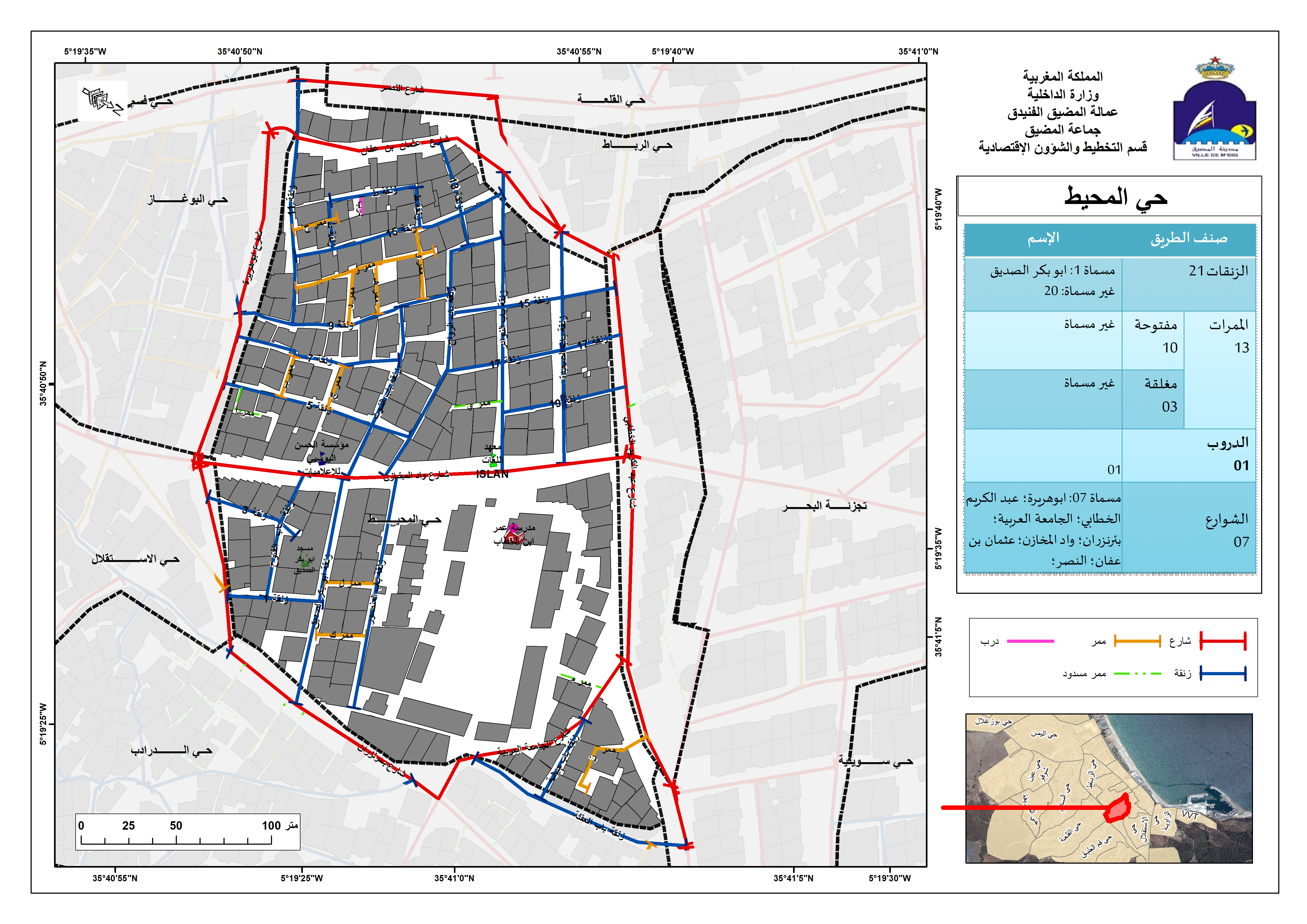

Street Addressing and Naming System
Spatial analysis
Spatial analysis
Shaded relief map
Raster to Geodatabase
Thematic maps
Thematic maps
Thematic maps
Thematic maps
Brochure with Business Card
Brochure with Business Card
Street Addressing and Naming System
리뷰
수정 사항에 대한 저장 완료
현재 1 ~ 5 번째 리뷰 표시 중(전체 9 건)
$150.00 USD
Data Processing
Data Mining
Geospatial
JSON

•
€40.00 EUR
N

•
$10.00 USD
PHP
Data Processing
Data Entry
Excel
Web Scraping
A
•
€90.00 EUR
N
•
$50.00 USD
Logo Design
Illustrator
Prezi
Geospatial
+1 건 추가

•
경력
GIS Specialist
1월 2018 - 현재
• Performed geospatial analyses;
• shared interactive maps and services in ArcGIS Online;
• Collected and processed Landsat images for M’diq city;
• Used GIS technique (Desktop/Mobile) and Microsoft Access in business activities survey;
• Mapped a land use plan for M'diq-Fnideq prefecture beach;
• Designed billboards for Beach;
• Created Gis-based Street Addressing and Naming System;
• Mapped a Traffic Signs plan for M’diq city;
• Created compelling visual presentations.
Cartographer/GIS
1월 2017 - 6월 2017 (5 , 1 )
Designed land use plan using Geographical Information System.
GIS Intern
8월 2016 - 9월 2016 (1 , 1 )
Created Geodatabase for Guelmim-Oued Noun Regional Roads.
교육
Master's degree, Territorial Development and Spatial Governance
(3 )
Bachelor's degree, Geography
(3 )
직업에 관해 Ayoub L.님에게 연락해보세요
채팅으로 자세한 내용을 논의하려면 로그인하세요.
인증
최고 기술
유사한 모범 사례 탐색
초대장 발송이 완료되었습니다!
감사합니다! 무료 크레딧을 신청할 수 있는 링크를 이메일로 보내드렸습니다.
이메일을 보내는 동안 문제가 발생했습니다. 다시 시도해 주세요.
클립보드로 복사하는 과정에서 문제가 발생하였습니다. 고객님의 권한 정보를 조정하신 후에 재시도하여 주시기 바랍니다.
클립보드로 복사되었습니다.
미리 보기 화면을 준비 중...
위치 정보 관련 접근권이 허용되었습니다.
고객님의 로그인 세션이 만료되어, 자동으로 로그아웃 처리가 되었습니다. 다시 로그인하여 주십시오.