

를 팔로우 했습니다.
팔로우 서비스의 지정 과정에서 문제가 발생하였습니다.
이 사용자의 경우에는 다른 사용자들의 팔로우 서비스를 허용하지 않고 있습니다.
이 사용자에 대한 팔로우 서비스를 이미 이용하고 계십니다.
고객님의 현재 멤버십 등급으로는 0 건까지만 팔로우가 가능합니다. 멤버십 서비스의 업그레이드는 여기에서 하시면 됩니다.
성공적으로 언팔로우했습니다
팔로우 서비스에 대한 지정 해제 과정에서 문제가 발생하였습니다.
님에 대한 고객님의 추천 절차가 모두 완료되었습니다.
사용자 추천 과정에서 문제가 발생하였습니다.
원인을 알 수 없는 문제가 발생하였습니다. 현재의 페이지에서 다시 읽기 버튼을 클릭하신 후에 재시도하여 주시기 바랍니다.

직업에 관해 Taron A.님에게 연락해보세요
채팅으로 자세한 내용을 논의하려면 로그인하세요.
포트폴리오
포트폴리오


Illustration of Debed Canyon
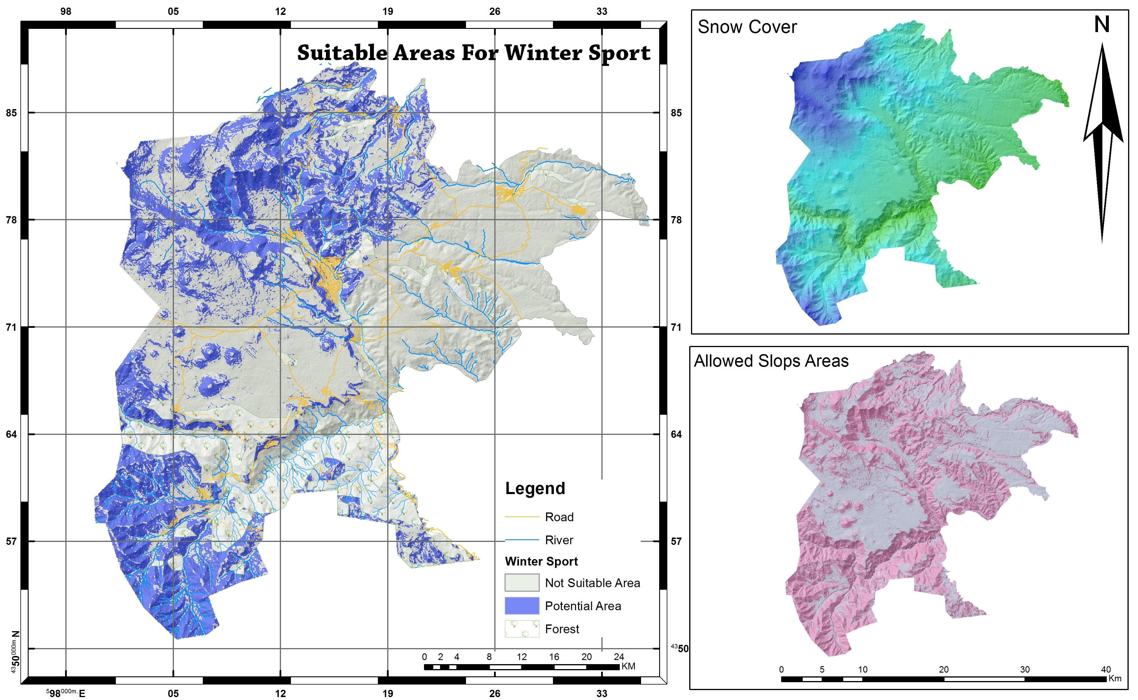

Suitable Areas For Winter Sports


Mapping of Electrical network and EIA areas
Illustration of Debed Canyon
Suitable Areas For Winter Sports
Mapping of Electrical network and EIA areas
리뷰
수정 사항에 대한 저장 완료
여기에는 더 확인하실 만한 리뷰 건이 없습니다!
경력
Chief Scientist and GIS specialist
9월 2019 - 현재
Data analyst, spatial database creation, decision support system development via GIS and Remote Sensing. Field measurements and managing scientific flow inside organization.
GIS specialist
10월 2017 - 9월 2019 (1 , 11 )
Data collection and maintenance, map production, data viewing and query, preparation of GIS databases, maps, database reports, and specialized queries in support of various projects, perform GIS analysis, modeling, and reporting to support decision making.
Researcher
7월 2017 - 11월 2017 (4 , 1 )
Modeling Distribution of Armenian Red Book Plant Species and Rare Ecosystems According Climate Change using GIS technologies.
직업에 관해 Taron A.님에게 연락해보세요
채팅으로 자세한 내용을 논의하려면 로그인하세요.
인증
자격증
유사한 모범 사례 탐색
초대장 발송이 완료되었습니다!
감사합니다! 무료 크레딧을 신청할 수 있는 링크를 이메일로 보내드렸습니다.
이메일을 보내는 동안 문제가 발생했습니다. 다시 시도해 주세요.
클립보드로 복사하는 과정에서 문제가 발생하였습니다. 고객님의 권한 정보를 조정하신 후에 재시도하여 주시기 바랍니다.
클립보드로 복사되었습니다.
미리 보기 화면을 준비 중...
위치 정보 관련 접근권이 허용되었습니다.
고객님의 로그인 세션이 만료되어, 자동으로 로그아웃 처리가 되었습니다. 다시 로그인하여 주십시오.